
Stadt Bregenz topographic map
Interactive map
Click on the map to display elevation.
About this map
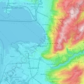
Name: Stadt Bregenz topographic map, elevation, terrain.
Location: Stadt Bregenz, Bezirk Bregenz, Vorarlberg, Austria (47.48002 9.65158 47.53466 9.80767)
Average elevation: 1,837 ft
Minimum elevation: 1,286 ft
Maximum elevation: 3,579 ft
Other topographic maps
Click on a map to view its topography, its elevation and its terrain.
Gemeinde Warth
Austria > Vorarlberg > Bezirk Bregenz
Gemeinde Warth, Bezirk Bregenz, Vorarlberg, 6767, Austria
Average elevation: 5,807 ft