
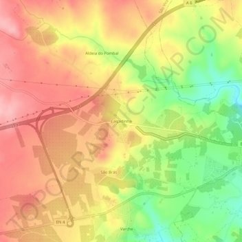
Calçadinha topographic map
Interactive map
Click on the map to display elevation.
About this map
Name: Calçadinha topographic map, elevation, terrain.
Average elevation: 1,165 ft
Minimum elevation: 902 ft
Maximum elevation: 1,352 ft
Other topographic maps
Click on a map to view its topography, its elevation and its terrain.
Vila Boim
Portugal > Portalegre > Elvas
Vila Boim, Elvas, Portalegre, 7350-501, Portugal
Average elevation: 1,473 ft
Barbacena
Portugal > Portalegre > Elvas
Barbacena, Elvas, Portalegre, 7350-431, Portugal
Average elevation: 1,155 ft