
Make a donation
Gear up for your next adventure:
As an Amazon Associate, this site earns from qualifying purchases at no extra cost to you.
Mouthe topographic map
Click on the map to display elevation.
Make a donation
Gear up for your next adventure:
As an Amazon Associate, this site earns from qualifying purchases at no extra cost to you.
Mouthe
Due to its elevation, Mouthe features a warm-summer humid continental climate (Dfb, according to the Köppen climate classification), with an average annual precipitation of 1,713 mm (67.44 in). Summers are mild while winters are very cold and snowy.
Make a donation
Gear up for your next adventure:
As an Amazon Associate, this site earns from qualifying purchases at no extra cost to you.
About this map
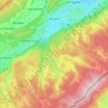
Name: Mouthe topographic map, elevation, terrain.
Average elevation: 3,737 ft
Minimum elevation: 3,022 ft
Maximum elevation: 4,626 ft
Make a donation
Gear up for your next adventure:
As an Amazon Associate, this site earns from qualifying purchases at no extra cost to you.
Other topographic maps
Click on a map to view its topography, its elevation and its terrain.