
Thank you for supporting this site ❤️
Make a donation
Make a donation
Gear up for your next adventure:
As an Amazon Associate, this site earns from qualifying purchases at no extra cost to you.
Plañel topographic map
Click on the map to display elevation.
Thank you for supporting this site ❤️
Make a donation
Make a donation
Gear up for your next adventure:
As an Amazon Associate, this site earns from qualifying purchases at no extra cost to you.
About this map
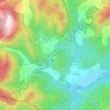
Name: Plañel topographic map, elevation, terrain.
Location: Plañel, Yeste, Albacete, Castilla-La Mancha, España (38.28448 -2.45232 38.32448 -2.41232)
Average elevation: 2,900 ft
Minimum elevation: 2,116 ft
Maximum elevation: 4,275 ft
Thank you for supporting this site ❤️
Make a donation
Make a donation
Gear up for your next adventure:
As an Amazon Associate, this site earns from qualifying purchases at no extra cost to you.