
Ballycummin topographic map
Interactive map
Click on the map to display elevation.
About this map
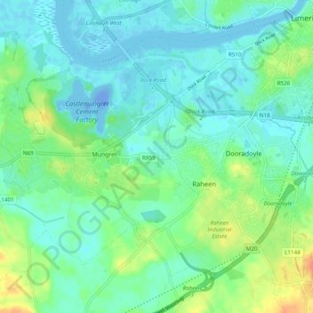
Name: Ballycummin topographic map, elevation, terrain.
Average elevation: 36 ft
Minimum elevation: -89 ft
Maximum elevation: 131 ft
Other topographic maps
Click on a map to view its topography, its elevation and its terrain.
Raheen Business Park
Ireland > The Metropolitan District of Limerick City
Raheen Business Park, Ballycummin, The Metropolitan District of Limerick City, County Limerick, Munster, V94 DY27, Ireland
Average elevation: 46 ft
Prior's-Land
Ireland > The Metropolitan District of Limerick City
Prior's-Land, Shannon B, The Metropolitan District of Limerick City, County Limerick, Munster, Ireland
Average elevation: 36 ft
Kilrush
Ireland > The Metropolitan District of Limerick City
Kilrush, Castle D, The Metropolitan District of Limerick City, County Limerick, Munster, Ireland
Average elevation: 23 ft
Moylish
Ireland > The Metropolitan District of Limerick City
Moylish, Ballynanty, The Metropolitan District of Limerick City, County Limerick, Munster, Ireland
Average elevation: 30 ft
Ballynanty
Ireland > The Metropolitan District of Limerick City
Ballynanty, The Metropolitan District of Limerick City, County Limerick, Munster, Ireland
Average elevation: 26 ft
Dromore
Ireland > The Metropolitan District of Limerick City
Dromore, Ballysimon, The Metropolitan District of Limerick City, County Limerick, Munster, V94 NYD3, Ireland
Average elevation: 43 ft
Stonetown
Ireland > The Metropolitan District of Limerick City
Stonetown, Castle C, The Metropolitan District of Limerick City, County Limerick, Munster, Ireland
Average elevation: 33 ft
Corbally
Ireland > The Metropolitan District of Limerick City
Corbally, Carrig, The Metropolitan District of Limerick City, County Limerick, Munster, Ireland
Average elevation: 39 ft
Laghtane East
Ireland > The Metropolitan District of Limerick City
Laghtane East, Ballyvarra, The Metropolitan District of Limerick City, County Limerick, Munster, Ireland
Average elevation: 112 ft
Dooradoyle
Ireland > The Metropolitan District of Limerick City
Dooradoyle, Ballycummin ED, The Metropolitan District of Limerick City, County Limerick, Munster, Ireland
Average elevation: 36 ft
Kings Island
Ireland > The Metropolitan District of Limerick City
Kings Island, John's A, The Metropolitan District of Limerick City, County Limerick, Munster, Ireland
Average elevation: 26 ft
Englishtown
Ireland > The Metropolitan District of Limerick City
Englishtown, John's B, The Metropolitan District of Limerick City, County Limerick, Munster, Ireland
Average elevation: 30 ft
Coonagh
Ireland > The Metropolitan District of Limerick City
Coonagh, Limerick North Rural, The Metropolitan District of Limerick City, County Limerick, Munster, V94 1X59, Ireland
Average elevation: 7 ft