
Beverly topographic map
Click on the map to display elevation.
About this map
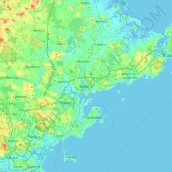
Name: Beverly topographic map, elevation, terrain.
Location: Beverly, Essex County, Massachusetts, 01915, United States (42.39843 -71.04005 42.71843 -70.72005)
Average elevation: 56 ft
Minimum elevation: -13 ft
Maximum elevation: 377 ft
Essex County trails, hiking, mountain biking, running and outdoor activities
Other topographic maps
Click on a map to view its topography, its elevation and its terrain.
Dix Park
United States > Massachusetts > Essex County > Beverly > Beverly Farms
Average elevation: 62 ft