
Francois Peron National Park topographic map
Interactive map
Click on the map to display elevation.
About this map
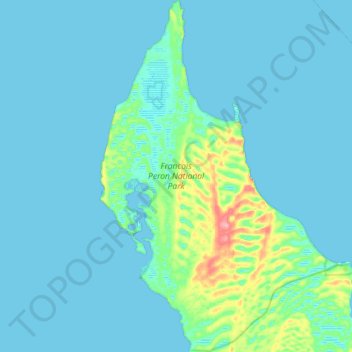
Name: Francois Peron National Park topographic map, elevation, terrain.
Average elevation: 30 ft
Minimum elevation: 0 ft
Maximum elevation: 272 ft
Other topographic maps
Click on a map to view its topography, its elevation and its terrain.
Little Lagoon
Australia > Western Australia > Denham
Little Lagoon, Shark Bay, Denham, Shire Of Shark Bay, Western Australia, Australia
Average elevation: 52 ft
Denham
Australia > Western Australia > Denham
Denham, Shire Of Shark Bay, Western Australia, 6537, Australia
Average elevation: 39 ft