
Make a donation
Gear up for your next adventure:
As an Amazon Associate, this site earns from qualifying purchases at no extra cost to you.
Uyuni topographic map
Click on the map to display elevation.
Make a donation
Gear up for your next adventure:
As an Amazon Associate, this site earns from qualifying purchases at no extra cost to you.
Uyuni
Founded in 1890 as a trading post, the city has a population of 29,672 (2012 official census). The town has an extensive street-market. It lies at the edge of an extensive plain at an elevation of 3,700 m (12,139 ft) above sea level, with more mountainous country to the east.
Make a donation
Gear up for your next adventure:
As an Amazon Associate, this site earns from qualifying purchases at no extra cost to you.
About this map
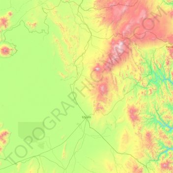
Name: Uyuni topographic map, elevation, terrain.
Location: Uyuni, Antonio Quijarro, Potosí, Bolivia (-20.99074 -67.27036 -19.35550 -66.18732)
Average elevation: 12,743 ft
Minimum elevation: 10,594 ft
Maximum elevation: 18,100 ft
Make a donation
Gear up for your next adventure:
As an Amazon Associate, this site earns from qualifying purchases at no extra cost to you.
Other topographic maps
Click on a map to view its topography, its elevation and its terrain.