
Swansea topographic map
Interactive map
Click on the map to display elevation.
About this map
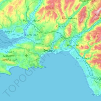
Name: Swansea topographic map, elevation, terrain.
Location: Swansea, Wales, SA1 3BN, United Kingdom (51.45960 -4.10592 51.77960 -3.78592)
Average elevation: 240 ft
Minimum elevation: -7 ft
Maximum elevation: 1,522 ft
Much of Swansea is hilly with the main area of upland being located in the council ward of Mawr. Areas up to 185 metres (607 ft) in elevation range across the central section: Kilvey Hill, Townhill and Llwynmawr separate the centre of Swansea from its northern suburbs. Cefn Bryn, a ridge of high land, is the backbone of the Gower Peninsula. Rhossili Down, Hardings Down and Llanmadoc Hill are up to 193 metres (633 ft) high. The highest point is located Penlle'r Castell at 374 metres (1,227 ft) on the northern border with Carmarthenshire.
Other topographic maps
Click on a map to view its topography, its elevation and its terrain.
Oxwich
United Kingdom > Wales > Swansea
Oxwich, Swansea, Wales, SA3 1LS, United Kingdom
Average elevation: 118 ft
Slade
United Kingdom > Wales > Swansea > Slade
Slade, Swansea, Wales, SA3 1NA, United Kingdom
Average elevation: 118 ft
Clydach
United Kingdom > Wales > Swansea > Clydach
Clydach, Swansea, Wales, United Kingdom
Average elevation: 364 ft
Morriston
United Kingdom > Wales > Swansea > Morriston
Morriston, Swansea, Wales, SA6 6DR, United Kingdom
Average elevation: 246 ft
Llansamlet
United Kingdom > Wales > Swansea
Llansamlet, Swansea, Wales, United Kingdom
Average elevation: 105 ft
Oxwich
United Kingdom > Wales > Swansea
Oxwich, Penrice, Slade, Oxwich, Swansea, Wales, United Kingdom
Average elevation: 135 ft