
Make a donation
Gear up for your next adventure:
As an Amazon Associate, this site earns from qualifying purchases at no extra cost to you.
Ibadan topographic map
Click on the map to display elevation.
Make a donation
Gear up for your next adventure:
As an Amazon Associate, this site earns from qualifying purchases at no extra cost to you.
Ibadan
Ibadan, coined from the phrase "Eba-Odan", which literally means 'by the edge of the meadow', came into existence in 1829, during a period of turmoil that characterized Yorubaland at the time. It was in this period that many old Yoruba cities such as old Oyo (Oyo-ile), Ijaye and Owu disappeared, and newer ones such as Abeokuta, new Oyo (Oyo Atiba) and Ibadan sprang up to replace them. According to local historians, Lagelu founded the city, and was initially intended to be a war camp for warriors coming from Oyo, Ife and Ijebu. As a forest site containing several ranges of hills, varying in elevation from 160 to 275 meters, the location of the camp offered strategic defense opportunities. Moreover, its location at the fringe of the forest (from which the city got its name) promoted its emergence as a marketing center for traders and goods from both the forest and grassland areas.
Make a donation
Gear up for your next adventure:
As an Amazon Associate, this site earns from qualifying purchases at no extra cost to you.
About this map
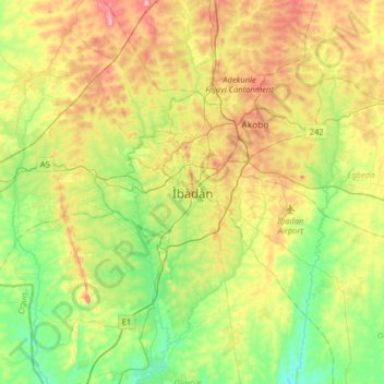
Name: Ibadan topographic map, elevation, terrain.
Location: Ibadan, Ibadan South West, Oyo State, 234102, Nigeria (7.21775 3.73725 7.53775 4.05725)
Average elevation: 627 ft
Minimum elevation: 302 ft
Maximum elevation: 1,138 ft
Make a donation
Gear up for your next adventure:
As an Amazon Associate, this site earns from qualifying purchases at no extra cost to you.