
Make a donation
Gear up for your next adventure:
As an Amazon Associate, this site earns from qualifying purchases at no extra cost to you.
Morrocoy National Park topographic map
Click on the map to display elevation.
Make a donation
Gear up for your next adventure:
As an Amazon Associate, this site earns from qualifying purchases at no extra cost to you.
Morrocoy National Park
The park's bays, mangroves, cays and islands sit in the shadow of the Chichiriviche hills, with elevations up to around 250 m. At 285 m high, Chichiriviche Hill is the highest point in the park. It stands amid the surrounding coastal environment of Tertiary-period coral origin, belonging to the Capadare - Agua Linda limestone geological formation.
Make a donation
Gear up for your next adventure:
As an Amazon Associate, this site earns from qualifying purchases at no extra cost to you.
About this map
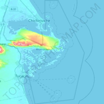
Name: Morrocoy National Park topographic map, elevation, terrain.
Average elevation: 33 ft
Minimum elevation: -10 ft
Maximum elevation: 928 ft
Make a donation
Gear up for your next adventure:
As an Amazon Associate, this site earns from qualifying purchases at no extra cost to you.