
Cranston topographic map
Interactive map
Click on the map to display elevation.
About this map
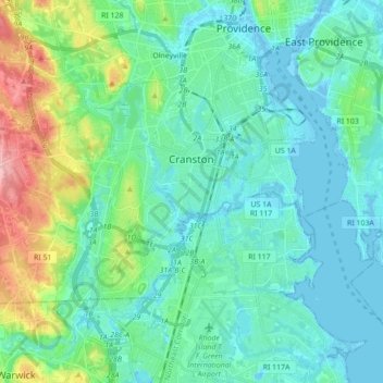
Name: Cranston topographic map, elevation, terrain.
Location: Cranston, Providence County, Rhode Island, United States (41.73007 -71.55929 41.80702 -71.38517)
Average elevation: 89 ft
Minimum elevation: -23 ft
Maximum elevation: 417 ft
Other topographic maps
Click on a map to view its topography, its elevation and its terrain.
Cumberland
United States > Rhode Island > Providence County
Cumberland, Providence County, Rhode Island, 02864, United States
Average elevation: 249 ft
Providence
United States > Rhode Island > Providence County
Providence, Providence County, Rhode Island, United States
Average elevation: 62 ft
Chopmist
United States > Rhode Island > Providence County > Scituate
Chopmist, Scituate, Providence County, Rhode Island, 02857, United States
Average elevation: 574 ft
Diamond Hill
United States > Rhode Island > Providence County > Cumberland
Diamond Hill, Cumberland, Providence County, Rhode Island, 02864, United States
Average elevation: 262 ft
East Providence
United States > Rhode Island > Providence County
East Providence, Providence County, Rhode Island, United States
Average elevation: 39 ft
James V. Turner Reservoir
United States > Rhode Island > Providence County > East Providence > Rumford
James V. Turner Reservoir, Rumford, East Providence, Providence County, Rhode Island, United States
Average elevation: 46 ft
Page Island
United States > Rhode Island > Providence County > Pascoag
Page Island, Pascoag, Providence County, Rhode Island, 02859, United States
Average elevation: 407 ft
Pawtucket
United States > Rhode Island > Providence County
Pawtucket, Providence County, Rhode Island, United States
Average elevation: 79 ft
Central Falls
United States > Rhode Island > Providence County
Central Falls, Providence County, Rhode Island, United States
Average elevation: 72 ft
Roosevelt Lake
United States > Rhode Island > Providence County > Providence
Roosevelt Lake, Providence, Providence County, Rhode Island, United States
Average elevation: 39 ft
North Providence
United States > Rhode Island > Providence County
North Providence, Providence County, Rhode Island, 02911, United States
Average elevation: 174 ft
Woonsocket
United States > Rhode Island > Providence County
Woonsocket, Providence County, Rhode Island, 02895, United States
Average elevation: 243 ft
Cunliff Pond Dam
United States > Rhode Island > Providence County > Providence
Cunliff Pond Dam, Providence, Providence County, Rhode Island, 02905, United States
Average elevation: 30 ft
Providence River
United States > Rhode Island > Providence County > Providence
Providence River, Providence, Providence County, Rhode Island, 02903, United States
Average elevation: 30 ft
North Smithfield
United States > Rhode Island > Providence County > North Smithfield
North Smithfield, Providence County, Rhode Island, United States
Average elevation: 315 ft
Burrillville
United States > Rhode Island > Providence County
Burrillville, Providence County, Rhode Island, United States
Average elevation: 509 ft
Smithfield
United States > Rhode Island > Providence County
Smithfield, Providence County, Rhode Island, United States
Average elevation: 351 ft
Saylesville
United States > Rhode Island > Providence County > Lincoln
Saylesville, Lincoln, Providence County, Rhode Island, 02863, United States
Average elevation: 121 ft
Town Line Swamp
United States > Rhode Island > Providence County > Lincoln
Town Line Swamp, Lincoln, Providence County, Rhode Island, United States
Average elevation: 361 ft
Glocester
United States > Rhode Island > Providence County
Glocester, Providence County, Rhode Island, United States
Average elevation: 545 ft
Valley Falls
United States > Rhode Island > Providence County > Cumberland
Valley Falls, Cumberland, Providence County, Rhode Island, 02863, United States
Average elevation: 92 ft
Chepachet
United States > Rhode Island > Providence County > Glocester
Chepachet, Glocester, Providence County, Rhode Island, 02814, United States
Average elevation: 472 ft
Olneyville
United States > Rhode Island > Providence County > Providence
Olneyville, Providence, Providence County, Rhode Island, 02909, United States
Average elevation: 79 ft