
Cranston topographic map
Click on the map to display elevation.
About this map
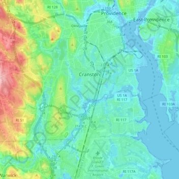
Name: Cranston topographic map, elevation, terrain.
Location: Cranston, Providence County, Rhode Island, United States (41.73007 -71.55929 41.80702 -71.38517)
Average elevation: 89 ft
Minimum elevation: -23 ft
Maximum elevation: 417 ft
Providence County trails, hiking, mountain biking, running and outdoor activities
Other topographic maps
Click on a map to view its topography, its elevation and its terrain.
Jerimoth Hill
United States > Rhode Island > Providence County > Foster
The hill is located on Route 101 in Foster, a half mile from the Connecticut line. To ascend the summit, for which there is a sign, there is a .3-mile (480 m) long trail that has a mere 10-foot (3.0 m) elevation gain. The hill is 812 feet (247 m) high and is located 15 miles (24 km) west of Providence, Rhode…
Average elevation: 709 ft
Diamond Hill Park
United States > Rhode Island > Providence County > Cumberland > Diamond Hill
Average elevation: 272 ft
Mountaindale
United States > Rhode Island > Providence County > Smithfield > Greenville
Average elevation: 272 ft
Jerimoth Hill
United States > Rhode Island > Providence County > Foster
The hill is located on Route 101 in Foster, a half mile from the Connecticut line. To ascend the summit, for which there is a sign, there is a 0.3-mile (480 m) long trail that has a mere 10-foot (3.0 m) elevation gain. The hill is 812 feet (247 m) high and is located 15 miles (24 km) west of Providence, Rhode…
Average elevation: 709 ft
Slatersville
United States > Rhode Island > Providence County > North Smithfield
Average elevation: 285 ft
Olneyville
United States > Rhode Island > Providence County > Providence > Olneyville
Average elevation: 79 ft