
Make a donation
Gear up for your next adventure:
As an Amazon Associate, this site earns from qualifying purchases at no extra cost to you.
Bampton topographic map
Click on the map to display elevation.
Make a donation
Gear up for your next adventure:
As an Amazon Associate, this site earns from qualifying purchases at no extra cost to you.
About this map
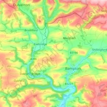
Name: Bampton topographic map, elevation, terrain.
Location: Bampton, Mid Devon, Devon, England, United Kingdom (50.97307 -3.54310 51.03148 -3.41106)
Average elevation: 607 ft
Minimum elevation: 269 ft
Maximum elevation: 1,033 ft
Make a donation
Gear up for your next adventure:
As an Amazon Associate, this site earns from qualifying purchases at no extra cost to you.
Other topographic maps
Click on a map to view its topography, its elevation and its terrain.
White Cross
United Kingdom > England > Devon > Mid Devon > Cheriton Fitzpaine
Average elevation: 430 ft
Bailey
United Kingdom > England > Devon > Mid Devon > Newton St. Cyres > Bailey
Average elevation: 299 ft
Make a donation
Gear up for your next adventure:
As an Amazon Associate, this site earns from qualifying purchases at no extra cost to you.