
Zouch topographic map
Interactive map
Click on the map to display elevation.
About this map
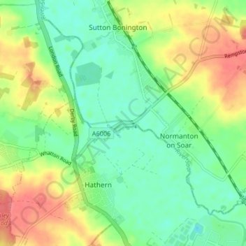
Name: Zouch topographic map, elevation, terrain.
Average elevation: 161 ft
Minimum elevation: 85 ft
Maximum elevation: 272 ft
Most of the hamlet lies in the civil parish of Sutton Bonington, apart from Zouch Farm which falls within Normanton on Soar parish, and the part in Leicestershire which is in Hathern parish. The nearest town is Loughborough. The A6006 road passes through the hamlet and crosses the Soar on Zouch Bridge (alternatively "County Bridge" as it spans the county border). The elevation of Zouch is 30 metres (98 ft).