
Ennigerloh topographic map
Interactive map
Click on the map to display elevation.
About this map
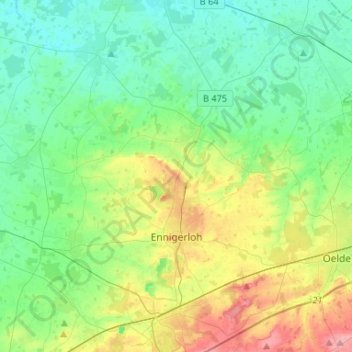
Name: Ennigerloh topographic map, elevation, terrain.
Average elevation: 269 ft
Minimum elevation: 177 ft
Maximum elevation: 489 ft
Other topographic maps
Click on a map to view its topography, its elevation and its terrain.
Beckum
Germany > North Rhine-Westphalia > Kreis Warendorf
Beckum, Kreis Warendorf, North Rhine-Westphalia, 59269, Germany
Average elevation: 361 ft
Wadersloh
Germany > North Rhine-Westphalia > Kreis Warendorf
Wadersloh, Kreis Warendorf, North Rhine-Westphalia, Germany
Average elevation: 285 ft
Westkirchen
Germany > North Rhine-Westphalia > Kreis Warendorf > Ennigerloh
Westkirchen, Ennigerloh, Kreis Warendorf, North Rhine-Westphalia, 59320, Germany
Average elevation: 262 ft