Geolocate

Burgas topographic map

Click on the map to display elevation.

About this map

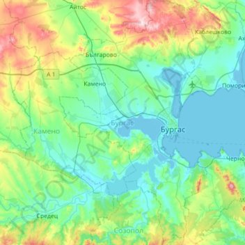
Name: Burgas topographic map, elevation, terrain.

Location: Burgas, Bulgaria (42.29557 27.20892 42.71300 27.57048)

Average elevation: 285 ft

Minimum elevation: -10 ft

Maximum elevation: 1,375 ft

Other topographic maps

Click on a map to view its topography, its elevation and its terrain.

Primorsko

Bulgaria > Burgas

Average elevation: 79 ft

Sozopol

Bulgaria > Burgas

Average elevation: 36 ft

Brashlyan

Bulgaria > Burgas

Average elevation: 1,158 ft

Kiten

Bulgaria > Burgas

Average elevation: 56 ft

Sozopol

Bulgaria > Burgas

Average elevation: 36 ft

Cape Emine

Bulgaria > Burgas > Emona

Average elevation: 85 ft

Skala

Bulgaria > Burgas

Average elevation: 1,289 ft

Tsarevo

Bulgaria > Burgas

Average elevation: 125 ft

Beronovo

Bulgaria > Burgas

Average elevation: 1,106 ft

Gabar

Bulgaria > Burgas

Average elevation: 272 ft

Slaviantsi

Bulgaria > Burgas

Average elevation: 902 ft

Dropla

Bulgaria > Burgas

Average elevation: 594 ft

Kiten

Bulgaria > Burgas

Average elevation: 56 ft

Zheleznik

Bulgaria > Burgas

Average elevation: 791 ft

Aytos

Bulgaria > Burgas

Average elevation: 489 ft

Burgas

Bulgaria > Burgas

Average elevation: 138 ft

Nesebar

Bulgaria > Burgas

Average elevation: 13 ft

Gear up for your next adventure:

🥄Camping Utensil Set - Lightweight utensils for outdoor meals
🗺️Topographic Maps - Detailed topo maps for hiking, exploring and outdoor navigation
🥤Water Filter Bottle - All‑in‑one filter bottle for safe hydration
🔦Compact Flashlight - Reliable flashlight for emergencies
🖼️Topo Map Wall Art - Decorative topographic prints of famous peaks and regions

As an Amazon Associate, this site earns from qualifying purchases at no extra cost to you.