
Make a donation
Gear up for your next adventure:
As an Amazon Associate, this site earns from qualifying purchases at no extra cost to you.
Denver topographic map
Click on the map to display elevation.
Make a donation
Gear up for your next adventure:
As an Amazon Associate, this site earns from qualifying purchases at no extra cost to you.
Denver
Denver, situated at an elevation of 5,280 feet (1,609 meters), is renowned as the "Mile High City." It is located in the South Platte River Valley, just east of the Rocky Mountains' foothills. The city's topography features a gently sloping landscape characterized by rolling hills and wide valleys, transitioning from the expansive High Plains to the west. The terrain is shaped by the nearby Rocky Mountains, with the peaks rising dramatically to the west and offering a striking contrast to the urban landscape. Denver's elevation ranges from approximately 4,973 feet (1,515 meters) at its lowest points to about 7,875 feet (2,397 meters) in the surrounding foothills, making it a unique blend of urban and mountainous environments.
Make a donation
Gear up for your next adventure:
As an Amazon Associate, this site earns from qualifying purchases at no extra cost to you.
About this map
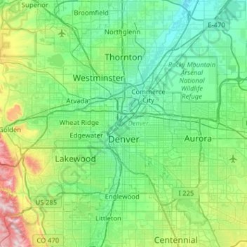
Name: Denver topographic map, elevation, terrain.
Location: Denver, Denver County, Colorado, United States (39.61432 -105.10988 39.91421 -104.59969)
Average elevation: 5,525 ft
Minimum elevation: 4,970 ft
Maximum elevation: 7,864 ft
Denver County trails, hiking, mountain biking, running and outdoor activities
Make a donation
Gear up for your next adventure:
As an Amazon Associate, this site earns from qualifying purchases at no extra cost to you.