
Make a donation
Gear up for your next adventure:
As an Amazon Associate, this site earns from qualifying purchases at no extra cost to you.
Juticalpa topographic map
Click on the map to display elevation.
Make a donation
Gear up for your next adventure:
As an Amazon Associate, this site earns from qualifying purchases at no extra cost to you.
Juticalpa
The climate is significantly warmer than Tegucigalpa or nearby Campamento because of the Valle de Juticalpa's elevation. Several thunderstorms occur during the period of May through September (wet season). October, November and December are cooler and often cloudy with drizzle. From January through April, the region receives very little rain (Dry Season). During this season field fires are often observed, some are intentionally created due to an old unlawful practice for renewing crops, and others are the result of severe heat or arson; these fires create a thick blanket of smoke that settles over the Juticalpa Valley for almost a month. The air improves after the first rain. During the rainy season, the incidence of dengue fever is quite high due to the many mud puddles that become breeding grounds for mosquitoes.
Make a donation
Gear up for your next adventure:
As an Amazon Associate, this site earns from qualifying purchases at no extra cost to you.
About this map
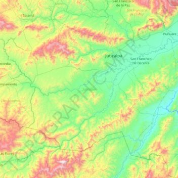
Name: Juticalpa topographic map, elevation, terrain.
Location: Juticalpa, Olancho, 16101, Honduras (14.27138 -86.67754 14.79292 -85.94007)
Average elevation: 2,119 ft
Minimum elevation: 751 ft
Maximum elevation: 5,997 ft
Make a donation
Gear up for your next adventure:
As an Amazon Associate, this site earns from qualifying purchases at no extra cost to you.
Other topographic maps
Click on a map to view its topography, its elevation and its terrain.
Campamento
Honduras > Olancho > Campamento
Campamento is located in a mountainous area with large areas of pine forests. Small farms cover the lower valleys in the area, predominantly growing beans and corn. The higher elevations support large coffee farms. Campamento is known for its large pine forests, which are harvested and processed in local…
Average elevation: 2,490 ft
Juticalpa
Honduras > Olancho > Juticalpa
The climate is significantly warmer than Tegucigalpa or nearby Campamento because of the Valle de Juticalpa's elevation. Several thunderstorms occur during the period of May through September (wet season). October, November and December are cooler and often cloudy with drizzle. From January through April, the…
Average elevation: 1,860 ft