
Make a donation
Gear up for your next adventure:
As an Amazon Associate, this site earns from qualifying purchases at no extra cost to you.
Mariquita topographic map
Click on the map to display elevation.
Make a donation
Gear up for your next adventure:
As an Amazon Associate, this site earns from qualifying purchases at no extra cost to you.
About this map
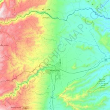
Name: Mariquita topographic map, elevation, terrain.
Location: Mariquita, Norte, Tolima, RAP (Especial) Central, Colombia (5.14173 -75.00936 5.31287 -74.79424)
Average elevation: 2,110 ft
Minimum elevation: 741 ft
Maximum elevation: 4,718 ft
Make a donation
Gear up for your next adventure:
As an Amazon Associate, this site earns from qualifying purchases at no extra cost to you.
Other topographic maps
Click on a map to view its topography, its elevation and its terrain.
Volcán Nevado del Ruiz
The summit of the volcano has steep slopes inclining from 20 to 30 degrees. At lower elevations, the slopes become less steep; their inclination is about 10 degrees. From there on, foothills stretch almost to the edge of the Magdalena River, north of the volcano and the Cauca River to the west. On the two…
Average elevation: 16,795 ft
Make a donation
Gear up for your next adventure:
As an Amazon Associate, this site earns from qualifying purchases at no extra cost to you.
Make a donation
Gear up for your next adventure:
As an Amazon Associate, this site earns from qualifying purchases at no extra cost to you.
Volcán Nevado del Ruiz
The summit of the volcano has steep slopes inclining from 20 to 30 degrees. At lower elevations, the slopes become less steep; their inclination is about 10 degrees. From there on, foothills stretch almost to the edge of the Magdalena River, north of the volcano and the Cauca River to the west. On the two…
Average elevation: 16,795 ft
Make a donation
Gear up for your next adventure:
As an Amazon Associate, this site earns from qualifying purchases at no extra cost to you.
Cordillera Central
The Cauca Valley montane forests ecoregion covers the western slope of the range. The Magdalena Valley montane forests cover the eastern slopes and the northern end of the cordillera. The Northern Andean páramo covers the highest elevations.
Average elevation: 12,159 ft