
Make a donation
Gear up for your next adventure:
As an Amazon Associate, this site earns from qualifying purchases at no extra cost to you.
Riobamba topographic map
Click on the map to display elevation.
Make a donation
Gear up for your next adventure:
As an Amazon Associate, this site earns from qualifying purchases at no extra cost to you.
Riobamba
Riobamba (Spanish pronunciation: [rjoˈβamba], full name San Pedro de Riobamba; Quechua: Rispampa) is the capital of Chimborazo Province in central Ecuador, and is located in the Chambo River Valley of the Andes. It is located 200 km (120 mi) south of Ecuador's capital Quito and situated at an elevation of 2,754 m.
Make a donation
Gear up for your next adventure:
As an Amazon Associate, this site earns from qualifying purchases at no extra cost to you.
About this map
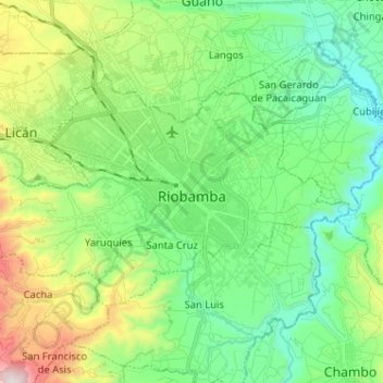
Name: Riobamba topographic map, elevation, terrain.
Location: Riobamba, Chimborazo, Ecuador (-1.71056 -78.72359 -1.63288 -78.59549)
Average elevation: 9,236 ft
Minimum elevation: 8,087 ft
Maximum elevation: 12,080 ft
Make a donation
Gear up for your next adventure:
As an Amazon Associate, this site earns from qualifying purchases at no extra cost to you.