Geolocate

Mathura topographic map

Click on the map to display elevation.

Mathura

Mathura is located at 27°17′N 77°25′E / 27.28°N 77.41°E / 27.28; 77.41. It has an average elevation of 174 metres (570 feet).

Wikipedia (CC-BY-SA 3.0)

About this map

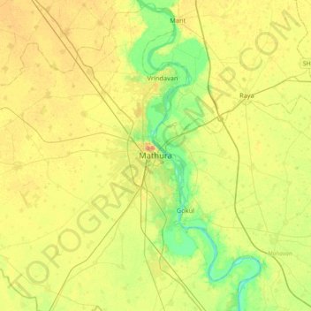
Name: Mathura topographic map, elevation, terrain.

Location: Mathura, Uttar Pradesh, 281001, India (27.33555 77.52556 27.65555 77.84556)

Average elevation: 581 ft

Minimum elevation: 518 ft

Maximum elevation: 640 ft

Other topographic maps

Click on a map to view its topography, its elevation and its terrain.

Chhata

India > Uttar Pradesh > Mathura

Average elevation: 604 ft

Gear up for your next adventure:

🪶Thermal Camp Blanket - Extra warmth for cold nights
🥤Water Filter Bottle - All‑in‑one filter bottle for safe hydration
🚁Photography Drones - Capture stunning aerial views of landforms and topography
🪶Compact Camp Shovel - Folding shovel for campsite tasks
📱Solar Portable Charger - Solar power bank for charging devices off‑grid

As an Amazon Associate, this site earns from qualifying purchases at no extra cost to you.