Geolocate

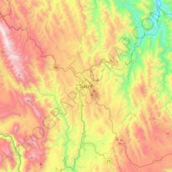
Sucre topographic map

Click on the map to display elevation.

Sucre

Sucre (Spanish: [ˈsukɾe]) is the de jure capital city of Bolivia, the capital of the Chuquisaca Department and the sixth most populous city in Bolivia. Located in the south-central part of the country, Sucre lies at an elevation of 2,790 m (9,150 ft). This relatively high altitude gives the city a subtropical highland climate with cool temperatures year-round. Over the centuries, the city has received various names, including La Plata, Charcas, and Chuquisaca.

Wikipedia (CC-BY-SA 3.0)

About this map

Name: Sucre topographic map, elevation, terrain.

Location: Sucre, Municipio Sucre, Provincia Oropeza, Chuquisaca, Bolivia (-19.20773 -65.41943 -18.88773 -65.09943)

Average elevation: 9,281 ft

Minimum elevation: 6,175 ft

Maximum elevation: 12,618 ft

Other topographic maps

Click on a map to view its topography, its elevation and its terrain.

Sanabria

Bolivia > Chuquisaca > Provincia Oropeza > Municipio Poroma

Average elevation: 9,724 ft

Municipio Sucre

Bolivia > Chuquisaca > Provincia Oropeza

Average elevation: 8,789 ft

Chaunaca

Bolivia > Chuquisaca > Provincia Oropeza > Municipio Sucre

Average elevation: 9,692 ft

Gear up for your next adventure:

🪶Trail Camera - Capture wildlife on your hikes
⌚Solar GPS Watches - Advanced multisport watches with built-in topographic maps
🛰️Satellite Messengers - Emergency SOS and two-way messaging for off-grid adventures
🛶Inflatable Kayak - Portable kayak for rivers, lakes, and expeditions
👓Polarized Sunglasses - Outdoor sunglasses for glare reduction

As an Amazon Associate, this site earns from qualifying purchases at no extra cost to you.