
Bemposta topographic map
Interactive map
Click on the map to display elevation.
About this map
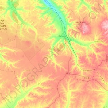
Name: Bemposta topographic map, elevation, terrain.
Location: Bemposta, Abrantes, Santarém, Portugal (39.23331 -8.28296 39.40929 -8.04684)
Average elevation: 564 ft
Minimum elevation: 144 ft
Maximum elevation: 863 ft
Other topographic maps
Click on a map to view its topography, its elevation and its terrain.
Vale Zebrinho
Portugal > Santarém > Abrantes
Vale Zebrinho, São Facundo e Vale das Mós, Abrantes, Santarém, Portugal
Average elevation: 525 ft
Rio de Moinhos
Portugal > Santarém > Abrantes
Rio de Moinhos, Abrantes, Santarém, 2200-799, Portugal
Average elevation: 230 ft
Arreciadas
Portugal > Santarém > Abrantes
Arreciadas, São Miguel do Rio Torto e Rossio ao Sul do Tejo, Abrantes, Santarém, 2205-013, Portugal
Average elevation: 282 ft
São Facundo
Portugal > Santarém > Abrantes > São Facundo
São Facundo, Abrantes, Santarém, Portugal
Average elevation: 607 ft
Alferrarede
Portugal > Santarém > Abrantes
Alferrarede, Abrantes, Santarém, Portugal
Average elevation: 308 ft