
Les combattants topographic map
Interactive map
Click on the map to display elevation.
About this map
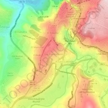
Name: Les combattants topographic map, elevation, terrain.
Average elevation: 1,814 ft
Minimum elevation: 1,181 ft
Maximum elevation: 2,346 ft
Other topographic maps
Click on a map to view its topography, its elevation and its terrain.
El Manchar
Algérie > Constantine > Daïra Constantine > Constantine
El Manchar, Constantine, Daïra Constantine, Constantine, 25017, Algérie
Average elevation: 1,745 ft
Ben Abdelmalek
Algérie > Constantine > Daïra Constantine > Constantine
Ben Abdelmalek, Constantine, Daïra Constantine, Constantine, 25100, Algérie
Average elevation: 2,041 ft
E'dkak
Algérie > Constantine > Daïra Constantine > Constantine
E'dkak, Constantine, Daïra Constantine, Constantine, 25017, Algérie
Average elevation: 1,765 ft
Oued Boumerzoug
Algérie > Constantine > Daïra Constantine > Constantine
Oued Boumerzoug, Constantine, Daïra Constantine, Constantine, 25100, Algérie
Average elevation: 2,110 ft
Belle Vue
Algérie > Constantine > Daïra Constantine > Constantine
Belle Vue, Constantine, Daïra Constantine, Constantine, 25017, Algérie
Average elevation: 1,785 ft