
Le Terme topographic map
Interactive map
Click on the map to display elevation.
About this map
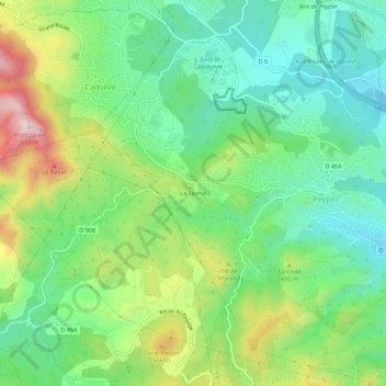
Name: Le Terme topographic map, elevation, terrain.
Average elevation: 1,191 ft
Minimum elevation: 732 ft
Maximum elevation: 2,083 ft
Other topographic maps
Click on a map to view its topography, its elevation and its terrain.
La Cride
France > Provence-Alpes-Côte d'Azur > Bouches-du-Rhône > Peypin
La Cride, Peypin, Marseille, Bouches-du-Rhône, Provence-Alpes-Côte d'Azur, France métropolitaine, 13124, France
Average elevation: 1,175 ft