
Rakáin topographic map
Interactive map
Click on the map to display elevation.
About this map
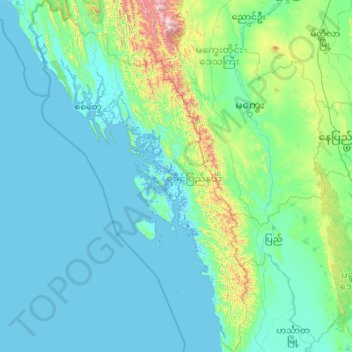
Name: Rakáin topographic map, elevation, terrain.
Location: Rakáin, Myanmar (17.33613 92.17194 21.47971 94.90184)
Average elevation: 512 ft
Minimum elevation: -13 ft
Maximum elevation: 9,718 ft
Other topographic maps
Click on a map to view its topography, its elevation and its terrain.
မာန်အောင်ကျွန်း
မာန်အောင်ကျွန်း, မာန်အောင်, ကျောက်ဖြူခရိုင်, Rakáin, Myanmar
Average elevation: 23 ft