Geolocate

Long topographic map

Click on the map to display elevation.

About this map

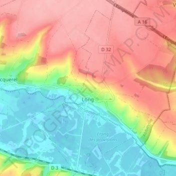
Name: Long topographic map, elevation, terrain.

Location: Long, Abbeville, Somme, Hauts-de-France, Metropolitan France, 80510, France (50.02096 1.95788 50.06299 2.01481)

Average elevation: 190 ft

Minimum elevation: 7 ft

Maximum elevation: 374 ft

Other topographic maps

Click on a map to view its topography, its elevation and its terrain.

Wadicourt

France > Hauts-de-France > Somme > Dompierre-sur-Authie

Average elevation: 217 ft

Le Quesnoy

France > Hauts-de-France > Somme > Parvillers-le-Quesnoy

Average elevation: 328 ft

Larronville

France > Hauts-de-France > Somme > Rue

Average elevation: 26 ft

Amiens

France > Hauts-de-France > Somme > Amiens

Average elevation: 282 ft

Gear up for your next adventure:

🔥Camping Stove - Portable stove for camping and backcountry cooking
🎁Geography Themed Gifts - Unique gift ideas for map lovers and geography enthusiasts
GPS Sports Watch - GPS watch for running, hiking and training
🧭Outdoor Navigation Book - Learn advanced navigation skills
🥘Titanium Cookware - Durable, featherlight pots and pans for backpacking

As an Amazon Associate, this site earns from qualifying purchases at no extra cost to you.