Geolocate

Rayleigh topographic map

Click on the map to display elevation.

About this map
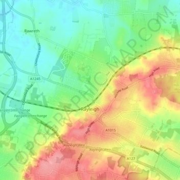
Name: Rayleigh topographic map, elevation, terrain.

Location: Rayleigh, Rochford, Essex, England, United Kingdom (51.57052 0.56227 51.61781 0.64926)

Average elevation: 121 ft

Minimum elevation: 3 ft

Maximum elevation: 282 ft

Other topographic maps

Click on a map to view its topography, its elevation and its terrain.

Rayleigh Mount

United Kingdom > England > Essex > Rochford > Rayleigh

Average elevation: 164 ft

Stroud Green

United Kingdom > England > Essex > Rochford

Average elevation: 72 ft

Gear up for your next adventure:

🔥Plasma Lighters - Windproof lighters that work in any weather condition
🛠️Outdoor Gear Repair Kit - Essential tools to fix gear on the trail
🏔️Mountain Trail Maps - High‑detail maps for popular peaks
🔭Telescopic Hiking Pole - Adjustable pole for hiking stability
📡GPS Antenna Upgrade - Enhance GPS reception in remote terrain

As an Amazon Associate, this site earns from qualifying purchases at no extra cost to you.