
Meden Vale topographic map
Interactive map
Click on the map to display elevation.
About this map
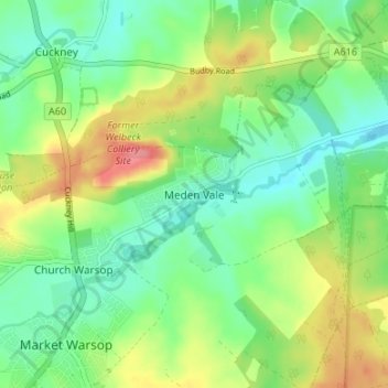
Name: Meden Vale topographic map, elevation, terrain.
Average elevation: 230 ft
Minimum elevation: 138 ft
Maximum elevation: 384 ft
Other topographic maps
Click on a map to view its topography, its elevation and its terrain.
Warsop Vale
United Kingdom > England > Nottinghamshire > Mansfield
Warsop Vale, Mansfield, Nottinghamshire, England, NG20 8XE, United Kingdom
Average elevation: 266 ft
River Meden
United Kingdom > England > Nottinghamshire > Mansfield > Warsop Vale
River Meden, Warsop, Warsop Vale, Mansfield, Nottinghamshire, England, NG20 0GB, United Kingdom
Average elevation: 233 ft
Church Warsop
United Kingdom > England > Nottinghamshire > Mansfield
Church Warsop, Mansfield, Nottinghamshire, England, NG20 0SN, United Kingdom
Average elevation: 240 ft