
Make a donation
Gear up for your next adventure:
As an Amazon Associate, this site earns from qualifying purchases at no extra cost to you.
Fairfield topographic map
Click on the map to display elevation.
Make a donation
Gear up for your next adventure:
As an Amazon Associate, this site earns from qualifying purchases at no extra cost to you.
About this map
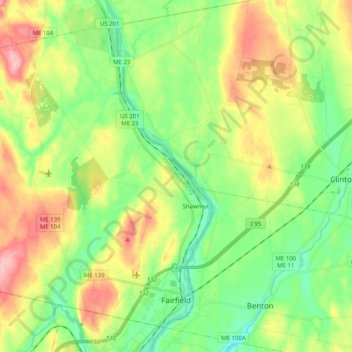
Name: Fairfield topographic map, elevation, terrain.
Location: Fairfield, Somerset County, Maine, United States (44.57732 -69.78027 44.70068 -69.57851)
Average elevation: 210 ft
Minimum elevation: 39 ft
Maximum elevation: 479 ft
Somerset County trails, hiking, mountain biking, running and outdoor activities
Make a donation
Gear up for your next adventure:
As an Amazon Associate, this site earns from qualifying purchases at no extra cost to you.
Other topographic maps
Click on a map to view its topography, its elevation and its terrain.
Rockwood
United States > Maine > Somerset County > Rockwood Strip T1 R1 NBKP
Average elevation: 1,086 ft
No Name Pond
United States > Maine > Somerset County > Bald Mountain Township T4 R3
Average elevation: 2,251 ft
Make a donation
Gear up for your next adventure:
As an Amazon Associate, this site earns from qualifying purchases at no extra cost to you.