
Thank you for supporting this site ❤️
Make a donation
Make a donation
Gear up for your next adventure:
As an Amazon Associate, this site earns from qualifying purchases at no extra cost to you.
Fouchana topographic map
Click on the map to display elevation.
Thank you for supporting this site ❤️
Make a donation
Make a donation
Gear up for your next adventure:
As an Amazon Associate, this site earns from qualifying purchases at no extra cost to you.
About this map
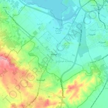
Name: Fouchana topographic map, elevation, terrain.
Location: Fouchana, الهضاب, معتمدية فوشانة, Ben Arous, 1145, Tunisia (36.65872 10.12936 36.73872 10.20936)
Average elevation: 138 ft
Minimum elevation: 7 ft
Maximum elevation: 449 ft
Thank you for supporting this site ❤️
Make a donation
Make a donation
Gear up for your next adventure:
As an Amazon Associate, this site earns from qualifying purchases at no extra cost to you.