
Hoddesdon topographic map
Interactive map
Click on the map to display elevation.
About this map
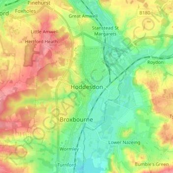
Name: Hoddesdon topographic map, elevation, terrain.
Average elevation: 177 ft
Minimum elevation: 56 ft
Maximum elevation: 344 ft
Other topographic maps
Click on a map to view its topography, its elevation and its terrain.
Kings Langley
United Kingdom > England > Hertfordshire > Dacorum
Kings Langley, Dacorum, Hertfordshire, England, United Kingdom
Average elevation: 364 ft
Ware
United Kingdom > England > Hertfordshire > East Hertfordshire
Ware, East Hertfordshire, Hertfordshire, England, United Kingdom
Average elevation: 180 ft
Hatfield
United Kingdom > England > Hertfordshire > Welwyn Hatfield
Hatfield, Welwyn Hatfield, Hertfordshire, England, United Kingdom
Average elevation: 295 ft
Ellenbrook Fields
United Kingdom > England > Hertfordshire > Welwyn Hatfield > Hatfield
Ellenbrook Fields, Hatfield Business Park, Hatfield, Welwyn Hatfield, Hertfordshire, East of England, England, United Kingdom
Average elevation: 262 ft
Hertford
United Kingdom > England > Hertfordshire > East Hertfordshire
Hertford, East Hertfordshire, Hertfordshire, England, United Kingdom
Average elevation: 200 ft
Hitchin
United Kingdom > England > Hertfordshire > North Hertfordshire > Hitchin
Hitchin, North Hertfordshire, Hertfordshire, East of England, England, SG5, United Kingdom
Average elevation: 299 ft
St Albans
United Kingdom > England > Hertfordshire > St Albans
St Albans, Hertfordshire, East of England, England, United Kingdom
Average elevation: 351 ft