Geolocate

Silver Lake topographic map

Click on the map to display elevation.

About this map

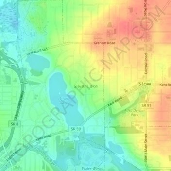
Name: Silver Lake topographic map, elevation, terrain.

Location: Silver Lake, Summit County, Ohio, United States (41.14436 -81.47043 41.17416 -81.44993)

Average elevation: 1,056 ft

Minimum elevation: 971 ft

Maximum elevation: 1,158 ft

Summit County trails, hiking, mountain biking, running and outdoor activities

Other topographic maps

Click on a map to view its topography, its elevation and its terrain.

Mud Brook Falls

United States > Ohio > Summit County > Cuyahoga Falls

Average elevation: 1,004 ft

Boston

United States > Ohio > Summit County

Average elevation: 804 ft

Greensburg

United States > Ohio > Summit County > Green

Average elevation: 1,175 ft

Metz

United States > Ohio > Summit County > Stow

Average elevation: 1,043 ft

Little Cuyahoga River

United States > Ohio > Summit County > Akron

Average elevation: 948 ft

Copley

United States > Ohio > Summit County

Average elevation: 1,043 ft

Sagamore Hills

United States > Ohio > Summit County

Average elevation: 866 ft

Maple Grove Park

United States > Ohio > Summit County > Hudson

Average elevation: 1,037 ft

Decker Park

United States > Ohio > Summit County > Barberton

Average elevation: 997 ft

Myersville

United States > Ohio > Summit County > Green

Average elevation: 1,122 ft

Metz

United States > Ohio > Summit County > Stow

Average elevation: 1,043 ft

Gear up for your next adventure:

🧦Merino Wool Socks - Moisture-wicking, blister-preventing socks for long treks
🌄Hiking Binoculars - Compact binoculars for scenic views and trail spotting
☀️Outdoor Sunscreen - High protection sunscreen for outdoor activities
🔭Telescopic Hiking Pole - Adjustable pole for hiking stability
🥤Water Filter Bottle - All‑in‑one filter bottle for safe hydration

As an Amazon Associate, this site earns from qualifying purchases at no extra cost to you.