Geolocate

Macabud topographic map

Click on the map to display elevation.

About this map

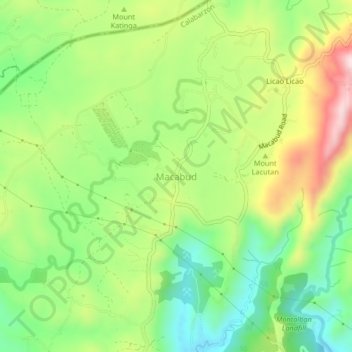
Name: Macabud topographic map, elevation, terrain.

Location: Macabud, Rizal, Calabarzon, Philippines (14.77757 121.11947 14.81757 121.15947)

Average elevation: 738 ft

Minimum elevation: 246 ft

Maximum elevation: 1,444 ft

Gear up for your next adventure:

☀️Outdoor Sunscreen - High protection sunscreen for outdoor activities
🍳Camping Cook Set - Complete cookware for outdoor meals
🧯Portable Fire Pit - Compact fire pit for camping spots
🌄Hiking Binoculars - Compact binoculars for scenic views and trail spotting
🥾Women's Hiking Boots - Top-rated trail boots with ankle support and superior grip

As an Amazon Associate, this site earns from qualifying purchases at no extra cost to you.