
Thank you for supporting this site ❤️
Make a donation
Make a donation
Gear up for your next adventure:
As an Amazon Associate, this site earns from qualifying purchases at no extra cost to you.
Chitungwiza topographic map
Click on the map to display elevation.
Thank you for supporting this site ❤️
Make a donation
Make a donation
Gear up for your next adventure:
As an Amazon Associate, this site earns from qualifying purchases at no extra cost to you.
About this map
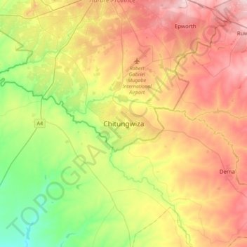
Name: Chitungwiza topographic map, elevation, terrain.
Location: Chitungwiza, Harare, Zimbabwe (-18.17435 30.91267 -17.85435 31.23267)
Average elevation: 4,718 ft
Minimum elevation: 4,337 ft
Maximum elevation: 5,164 ft
Thank you for supporting this site ❤️
Make a donation
Make a donation
Gear up for your next adventure:
As an Amazon Associate, this site earns from qualifying purchases at no extra cost to you.