
Make a donation
Gear up for your next adventure:
As an Amazon Associate, this site earns from qualifying purchases at no extra cost to you.
Maturin topographic map
Click on the map to display elevation.
Make a donation
Gear up for your next adventure:
As an Amazon Associate, this site earns from qualifying purchases at no extra cost to you.
Maturin
Maturin is located at 67 meters of altitude and 520 kilometres from the country's capital, Caracas. It is right next to the Guarapiche River and is a crossroad for roads towards the center, the Caribbean coast and the Orinoco River
Make a donation
Gear up for your next adventure:
As an Amazon Associate, this site earns from qualifying purchases at no extra cost to you.
About this map
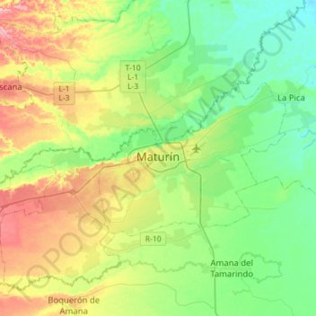
Name: Maturin topographic map, elevation, terrain.
Average elevation: 190 ft
Minimum elevation: 39 ft
Maximum elevation: 492 ft
Make a donation
Gear up for your next adventure:
As an Amazon Associate, this site earns from qualifying purchases at no extra cost to you.
Other topographic maps
Click on a map to view its topography, its elevation and its terrain.