
Houghall topographic map
Interactive map
Click on the map to display elevation.
About this map
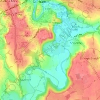
Name: Houghall topographic map, elevation, terrain.
Average elevation: 226 ft
Minimum elevation: 98 ft
Maximum elevation: 351 ft
Other topographic maps
Click on a map to view its topography, its elevation and its terrain.
City of Durham
United Kingdom > England > County Durham > Durham
City of Durham, Durham, County Durham, North East, England, United Kingdom
Average elevation: 249 ft
Observatory Hill
United Kingdom > England > County Durham > Durham
Observatory Hill, Durham, County Durham, North East, England, DH1 4SZ, United Kingdom
Average elevation: 240 ft
Pelton Fell
United Kingdom > England > County Durham > Durham
Pelton Fell, Durham, County Durham, North East, England, DH2 2QA, United Kingdom
Average elevation: 249 ft
Flass Vale Local Nature Reserve
United Kingdom > England > County Durham > Durham
Flass Vale Local Nature Reserve, Durham North End Allotments, City of Durham, Durham, County Durham, North East, England, United Kingdom
Average elevation: 266 ft