
Make a donation
Gear up for your next adventure:
As an Amazon Associate, this site earns from qualifying purchases at no extra cost to you.
Hayravanq topographic map
Click on the map to display elevation.
Make a donation
Gear up for your next adventure:
As an Amazon Associate, this site earns from qualifying purchases at no extra cost to you.
About this map
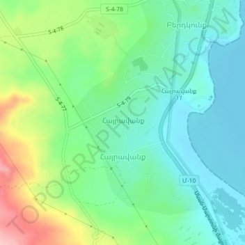
Name: Hayravanq topographic map, elevation, terrain.
Location: Hayravanq, Gavar region, Gegharkunik Province, Armenia (40.41995 45.08826 40.44026 45.10768)
Average elevation: 6,398 ft
Minimum elevation: 6,224 ft
Maximum elevation: 6,795 ft
Make a donation
Gear up for your next adventure:
As an Amazon Associate, this site earns from qualifying purchases at no extra cost to you.
Other topographic maps
Click on a map to view its topography, its elevation and its terrain.
Lake Sevan
Armenia > Gegharkunik Province
Lake Sevan (Armenian: Սևանա լիճ, romanized: Sevana lich) is the largest body of water in both Armenia and the Caucasus region. It is one of the largest freshwater high-altitude (alpine) lakes in Eurasia. The lake is situated in Gegharkunik Province, at an altitude of 1,900 m (6,234 ft) above sea level.…
Average elevation: 6,644 ft