
Make a donation
Gear up for your next adventure:
As an Amazon Associate, this site earns from qualifying purchases at no extra cost to you.
Lambesc topographic map
Click on the map to display elevation.
Make a donation
Gear up for your next adventure:
As an Amazon Associate, this site earns from qualifying purchases at no extra cost to you.
About this map
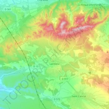
Name: Lambesc topographic map, elevation, terrain.
Average elevation: 764 ft
Minimum elevation: 325 ft
Maximum elevation: 1,568 ft
Make a donation
Gear up for your next adventure:
As an Amazon Associate, this site earns from qualifying purchases at no extra cost to you.
Other topographic maps
Click on a map to view its topography, its elevation and its terrain.
Aix-en-Provence
France > Provence-Alpes-Côte d'Azur > Bouches-du-Rhône > Aix-en-Provence
Average elevation: 915 ft
Matheron
France > Provence-Alpes-Côte d'Azur > Bouches-du-Rhône > Pélissanne
Average elevation: 390 ft
Bassin du Vallon Dol
France > Provence-Alpes-Côte d'Azur > Bouches-du-Rhône > Marseille
Average elevation: 791 ft
Mont Saint-Cyr
France > Provence-Alpes-Côte d'Azur > Bouches-du-Rhône > Marseille
Average elevation: 1,253 ft
Make a donation
Gear up for your next adventure:
As an Amazon Associate, this site earns from qualifying purchases at no extra cost to you.
Le Garlaban
France > Provence-Alpes-Côte d'Azur > Bouches-du-Rhône > Aubagne
Average elevation: 1,503 ft
Barrage de Bimont
France > Provence-Alpes-Côte d'Azur > Bouches-du-Rhône > Saint-Marc-Jaumegarde
Average elevation: 1,161 ft
Le Baguier
France > Provence-Alpes-Côte d'Azur > Bouches-du-Rhône > La Ciotat
Average elevation: 417 ft
La Cride
France > Provence-Alpes-Côte d'Azur > Bouches-du-Rhône > Le Puy-Sainte-Réparade
Average elevation: 997 ft
Make a donation
Gear up for your next adventure:
As an Amazon Associate, this site earns from qualifying purchases at no extra cost to you.