
Parres topographic map
Interactive map
Click on the map to display elevation.
About this map
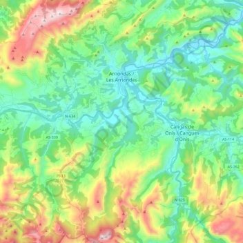
Name: Parres topographic map, elevation, terrain.
Location: Parres, Asturias, España (43.27667 -5.26944 43.44079 -5.08548)
Average elevation: 1,142 ft
Minimum elevation: 16 ft
Maximum elevation: 3,753 ft
Other topographic maps
Click on a map to view its topography, its elevation and its terrain.
Las Dueñas
Las Dueñas, Parres, Asturias, 33550, España
Average elevation: 1,352 ft
Cuadroveña
España > Asturias > Parres > Arriondas
Cuadroveña, Arriondas, Parres, Asturias, 33540, España
Average elevation: 410 ft