
Het Hogeland topographic map
Interactive map
Click on the map to display elevation.
About this map
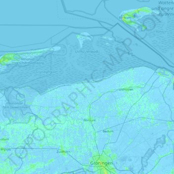
Name: Het Hogeland topographic map, elevation, terrain.
Location: Het Hogeland, Groningen, Netherlands, The Netherlands (53.24945 6.16743 53.57642 6.91179)
Average elevation: 0 ft
Minimum elevation: -23 ft
Maximum elevation: 59 ft
Other topographic maps
Click on a map to view its topography, its elevation and its terrain.
Bedum
The Netherlands > Groningen > Het Hogeland
Bedum, Het Hogeland, Groningen, Netherlands, The Netherlands
Average elevation: 0 ft
Winsum
The Netherlands > Groningen > Het Hogeland
Winsum, Het Hogeland, Groningen, Netherlands, The Netherlands
Average elevation: 3 ft