
Barangka Ilaya topographic map
Interactive map
Click on the map to display elevation.
About this map
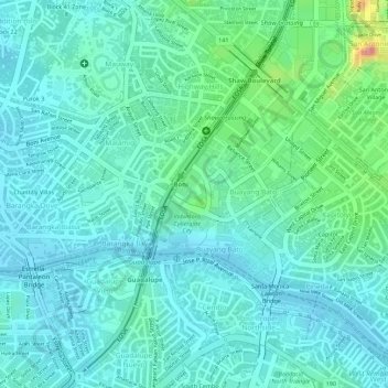
Name: Barangka Ilaya topographic map, elevation, terrain.
Location: Barangka Ilaya, Mandaluyong, Grand Manille, Philippines (14.56840 121.04263 14.57676 121.05152)
Average elevation: 82 ft
Minimum elevation: 13 ft
Maximum elevation: 328 ft
Other topographic maps
Click on a map to view its topography, its elevation and its terrain.
Mandaluyong
Mandaluyong, Grand Manille, 1551, Philippines
Average elevation: 108 ft