Geolocate

Grays topographic map

Click on the map to display elevation.

About this map

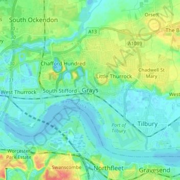
Name: Grays topographic map, elevation, terrain.

Location: Grays, Thurrock, England, RM17 6NP, United Kingdom (51.43809 0.28331 51.51809 0.36331)

Average elevation: 46 ft

Minimum elevation: -16 ft

Maximum elevation: 177 ft

Gear up for your next adventure:

🚪Portable Camp Chair - Foldable chair for comfort at camp
🛡️Insect Repellent - Protection against bugs during outdoor activities
🗺️NatGeo Topo Maps - High-quality waterproof printed topographic maps of US Parks
🥇GPS Hiking Watch - Multi‑sport GPS watch with navigation and trail tracking
📶Vehicle Signal Boosters - Improve reception in rural areas while driving to trailheads

As an Amazon Associate, this site earns from qualifying purchases at no extra cost to you.