
Lichfield topographic map
Interactive map
Click on the map to display elevation.
About this map
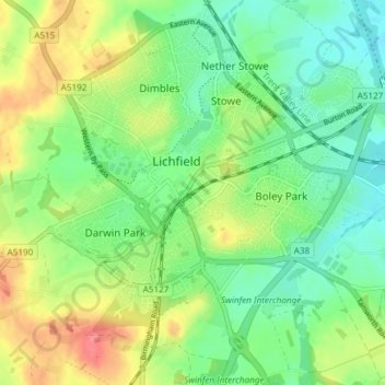
Name: Lichfield topographic map, elevation, terrain.
Location: Lichfield, Staffordshire, England, United Kingdom (52.65791 -1.86523 52.70326 -1.79271)
Average elevation: 299 ft
Minimum elevation: 200 ft
Maximum elevation: 459 ft
Other topographic maps
Click on a map to view its topography, its elevation and its terrain.
Grove Hill
United Kingdom > England > Staffordshire > Lichfield
Grove Hill, Lichfield, Staffordshire, England, WS9 9HJ, United Kingdom
Average elevation: 466 ft
Drayton Bassett
United Kingdom > England > Staffordshire > Lichfield > Drayton Basset
Drayton Bassett, Drayton Basset, Lichfield, Staffordshire, England, United Kingdom
Average elevation: 272 ft
Alrewas
United Kingdom > England > Staffordshire > Lichfield > Alrewas
Alrewas, Lichfield, Staffordshire, West Midlands, England, United Kingdom
Average elevation: 194 ft