
Make a donation
Gear up for your next adventure:
As an Amazon Associate, this site earns from qualifying purchases at no extra cost to you.
Seealpsee topographic map
Click on the map to display elevation.
Make a donation
Gear up for your next adventure:
As an Amazon Associate, this site earns from qualifying purchases at no extra cost to you.
Seealpsee
Seealpsee is a lake in the Alpstein range of the canton of Appenzell Innerrhoden, Switzerland. At an elevation of 1,143.2 m, the surface area is 13.6 hectares (34 acres). The lake can be reached by foot from Wasserauen or from Ebenalp. It is a popular tourist destination. A network of routes around Ebenalp connects Seealpsee with other notable sights in the Appenzell Alps, such as the Wildkirchli and Säntis. The Seealpsee provides hydroelectric power and drinking water to the town of Appenzell through the Kraftwerk Seealpsee-Wasserauen [de], which is run by the Feuerschaugemeinde.
Make a donation
Gear up for your next adventure:
As an Amazon Associate, this site earns from qualifying purchases at no extra cost to you.
About this map
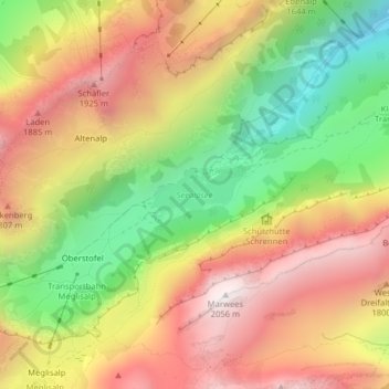
Name: Seealpsee topographic map, elevation, terrain.
Average elevation: 4,892 ft
Minimum elevation: 2,953 ft
Maximum elevation: 6,677 ft
Make a donation
Gear up for your next adventure:
As an Amazon Associate, this site earns from qualifying purchases at no extra cost to you.