
Bisingen topographic map
Interactive map
Click on the map to display elevation.
About this map
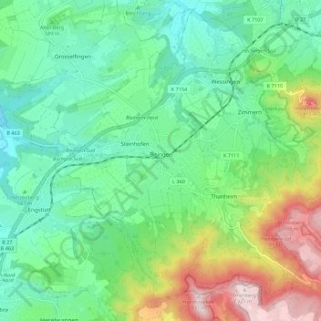
Name: Bisingen topographic map, elevation, terrain.
Average elevation: 1,998 ft
Minimum elevation: 1,572 ft
Maximum elevation: 3,041 ft
Bisingen is physically located along the northern edge of the Swabian Jura, between the Hundsrücken and the Hohenzollern mountains. Elevation above sea level in the municipal area ranges from a low of 485 meters (1,591 ft) Normalnull (NN) on the Klingenbach to a high of 912 meters (2,992 ft) NN at the top of the Zeller Horn.