Geolocate

Greenock topographic map

Click on the map to display elevation.

About this map

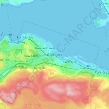
Name: Greenock topographic map, elevation, terrain.

Location: Greenock, Inverclyde, Scotland, PA15 1LS, United Kingdom (55.90734 -4.79647 55.98734 -4.71647)

Average elevation: 262 ft

Minimum elevation: -7 ft

Maximum elevation: 988 ft

Other topographic maps

Click on a map to view its topography, its elevation and its terrain.

Gear up for your next adventure:

📚USA Hiking Guide Books - Top trail guides and map books
🧢Sun Protection Hats - Wide-brimmed and UPF-rated hats for high-altitude sun safety
🎁Geography Themed Gifts - Unique gift ideas for map lovers and geography enthusiasts
😴Insulated Sleeping Pads - Compact and warm pads for high-elevation camping
🧭GPS Watch Accessories - Bands and chargers for GPS watches

As an Amazon Associate, this site earns from qualifying purchases at no extra cost to you.