
Sierra Madrona topographic map
Interactive map
Click on the map to display elevation.
About this map
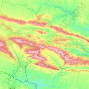
Name: Sierra Madrona topographic map, elevation, terrain.
Average elevation: 2,470 ft
Minimum elevation: 1,447 ft
Maximum elevation: 4,327 ft
Other topographic maps
Click on a map to view its topography, its elevation and its terrain.
Bañuela
España > Castilla-La Mancha > Sierra Morena > Fuencaliente
Bañuela, Fuencaliente, Sierra Morena, Ciudad Real, Castilla-La Mancha, España
Average elevation: 3,510 ft
El Hoyo
España > Castilla-La Mancha > Sierra Morena > Mestanza
El Hoyo, Mestanza, Sierra Morena, Ciudad Real, Castilla-La Mancha, España
Average elevation: 1,946 ft
Fuencaliente
España > Castilla-La Mancha > Sierra Morena > Fuencaliente
Fuencaliente, Sierra Morena, Ciudad Real, Castilla-La Mancha, España
Average elevation: 2,507 ft
Ventillas
España > Castilla-La Mancha > Sierra Morena > Fuencaliente > Ventillas
Ventillas, Fuencaliente, Sierra Morena, Ciudad Real, Castilla-La Mancha, España
Average elevation: 2,546 ft
Mestanza
España > Castilla-La Mancha > Sierra Morena > Mestanza
Mestanza, Sierra Morena, Ciudad Real, Castilla-La Mancha, España
Average elevation: 2,379 ft