Geolocate

Mbeya topographic map

Click on the map to display elevation.

Mbeya

Mbeya is situated at an altitude of 1,700 metres (5,500 ft), and sprawls through a narrow highland valley surrounded by a bowl of high mountains. The main language is colloquial Swahili, and the English language is extensively taught in schools.

Wikipedia (CC-BY-SA 3.0)

About this map

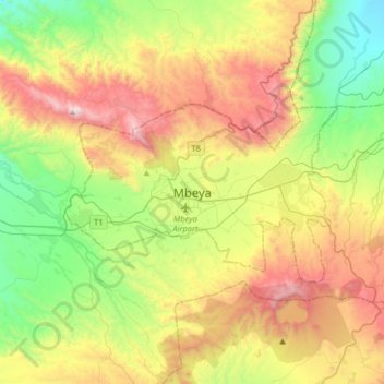
Name: Mbeya topographic map, elevation, terrain.

Location: Mbeya, Mbeya Municipal, Mbeya Region, Southern Highlands Zone, Tanzania (-9.06651 33.30867 -8.74651 33.62867)

Average elevation: 5,961 ft

Minimum elevation: 3,789 ft

Maximum elevation: 9,245 ft

Other topographic maps

Click on a map to view its topography, its elevation and its terrain.

Kyela

Tanzania > Mbeya Region

Average elevation: 2,205 ft

Iwambi

Tanzania > Mbeya Region

Average elevation: 5,115 ft

Iyela

Tanzania > Mbeya Region

Average elevation: 5,597 ft

Itezi

Tanzania > Mbeya Region

Average elevation: 6,148 ft

Gear up for your next adventure:

🌡️Portable Weather Meter - Track weather conditions on the trail
😴Insulated Sleeping Pads - Compact and warm pads for high-elevation camping
🎁Geography Themed Gifts - Unique gift ideas for map lovers and geography enthusiasts
🪶Paracord Bracelet - Survival bracelet with built‑in tools
🪶Survival Guide Book - Expert advice for emergency preparedness

As an Amazon Associate, this site earns from qualifying purchases at no extra cost to you.